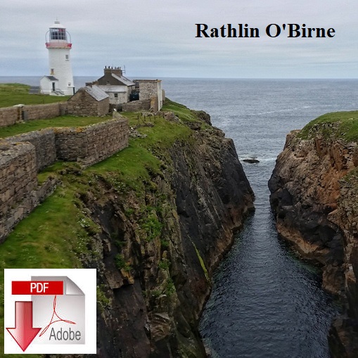
Rathlin O'Birne island lives along the coast from the much better known Slieve League sea cliffs, it is County Donegal's most westerly point. It is easily seen from the Bunglass viewpoint at the Slieve League road end. The island sits two kilometres west of the Malin Beg coastline at the south-west tip of Donegal. It is a low laying, grassy 65-acre uninhabited island.
The island's lighthouse in 1974 was the first nuclear-powered lighthouse in Ireland and was said to be the most powerful in the country at the time. With the march of technological progress wind power replaced the nuclear-powered cells and in 1987 and in 1993 solar power and unmanned operation of the lighthouse took over.

The easiest and shortest access to the island is to kayak from the public slipway at Malin Beg. From here it is a 3-kilometre paddle out to Rathlin O'Birne via Gloster Rock at Tharal Point at the south-west tip of mainland Donegal. The best landing on the island is in the sheltered wee bay on the east side of the island. With the predominant south-west sea motion, this sea crossing can be must harder and bumpier than it looks with the tide racing between the island and mainland Donegal.
The 8 foot high walls that surround the lighthouse are a work of art as they extend on both sides of the path from the lighthouse buildings right down to the beach on the west coast of the island. They must have provided excellent shelter for the lighthouse keepers journeys to and from the raised shingle landing beach on the east side of the island